Wednesday, December 12, 2007

200 lbs of Clothes 20,300 feet of Mountain - Part 2

Part 2 of Connie Garretts climb of Kyajo Ri in Nepal. As part of her trip she delivered over 200 lbs of gear to the Sherpa Climbing School that she rounded up from blog readers and locals in Bozeman.


...continued from part 1

Within a few days of leaving Namche we arrived in Gokyo, stopping along the way in Machherma where we got our first view of Kyajo Ri. Gokyo is a lake-side village pretty much at the end of this branch of the Khumbu highway. Continuing north, the trail becomes very faint and ultimately ends at the Gyazumba Glacier and Cho Oyu. The Ngozumba Glacier, the longest glacier in Nepal, separates Gokyo from anything but view to the west. Gokyo has some of the most breathtaking views of this region. Cho Oyu is north, the Everest stream of mountains is the to the west, including Pumori, Lhotse, and Lhotse Shar and to the east is Gokyo Ri and Renjo La (pass). Our team crossed Renjo La and continued south back towards Namche on a trail less traveled. In Thame, a 2-day trek from Gokyo, we headed toward Mende and back north again into the 14,800-foot valley that would be our base camp for Kyajo Ri.

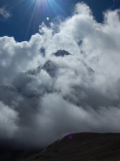
Kyajo Ri stands 20,300 feet and is considered a trekking peak in Nepal. Trekking peaks are defined by height, not by technical difficulty. Climbing Kyajo Ri from Mende is the least technical route with about 10-12 pitches of snow and ice for the last 1000 feet. From base camp there are two steep boulder ascents. The first boulder ascent brings climbers to a lake valley before the second boulder ascent. Each boulder ascent is about 1500 feet. Camp 1 was established at the top of the second boulder ascent at 17,300 feet. From Camp 1, our team established a high camp at 18,500 feet. Kyajo Ri can be climbed from Camp 1 in a long 15-20 hour push. The climb from Camp 1 to High Camp crosses the Kyajo Glacier and ascends another boulder field. Our team set up fixed ropes, which are completely unnecessary. At approximately 18,700 feet a col is reached. From there teams may elect to rope up for safety. Accomplished climbers can easily simu-climb from the col until at least 19,700 feet. Our team elected to belay from this point. Approximately 10-12 pitches from the col will bring climbers to the narrow snow-covered summit.

Plagued with head colds, tonsillitis, and an assortment of ailments, our team waited an extra two days in base camp. This was just long enough for the weather to change from t-shirts and knickers to long underwear and down suits. We found ourselves grossly unprepared for sub-zero temperatures in every way possible. The snow was too hard for pickets and too soft for ice screws. On summit day we treaded forward in the wee hours of the morning, waiting for the sunrise in hopes of warming the ambient air temperature. Pitch after pitch demanded intense anchor placement and each anchor became more and more difficult to build as the snow hardened with the westerly bitter cold wind. At 19,700-ft we found our feet frozen and our enthusiasm dwindling. With the summit just 600-ft above and completely within view it tears at something deep inside your core to turn around; a bitter defeat as the mountain wins again.

Even defeat on a mountain can be success overall through the lessons learned, experiences gained, or charity provided. In Nepal technical climbing gear is a much needed commodity as the porters only make about $10 per day and are not able to work year-round. One gore-tex jacket will cost a month’s salary for a Nepali. Those interested in continuing to donate technical clothing should contact one of the organizations above.

As for this mountaineer, it’s time to start planning for the next climb—Denali, spring 2008.

Labels: , ,

0 comments

Tuesday, December 11, 2007

200 lbs of Clothes 20,300 feet of Mountain - Part 1

This Adventure Report comes from Connie Garrett of Bozeman, Montana who last month set off to climb Kyajo Ri in Nepal and who along the way delivered over 200 lbs of gear to the Sherpa Climbing School that she rounded up from blog readers and locals in Bozeman.


Butterflies held a field dance in my stomach as I boarded the flight from Bozeman for the Khumbu in Nepal with 200 lbs of donated winter clothes shoveled into 4 duffel sacs. By the time I return from climbing there would be ice in Hyalite, snow on the ground, and leafless trees echoing in the winter wind.

Our climb of Kyajo Ri became a vehicle for delivering much needed technical clothing for Nepali high altitude workers. It all started as an easy way to distribute a few unwanted jackets from my closet and turned into a clothing drive resulting in 200 lbs of technical winter gear. Items were received from as far away as Edmonton, Alberta in Canada and as close as my closet, ranging in techno-colored gear from the 80’s to items featured in last year’s catalogues. All of the donated clothing was distributed to the Khumbu Climbing School, Porters Progress, and Inter-Mountain Explorer’s Connection.

Our plan was to climb Kyajo Ri, just a day’s jaunt from Namche to the north. For acclimatization, scenery, and a taste of the Khumbu our team circumnavigated the mountain before trekking into base camp. The Khumbu highway has two main branches from Lukla—one to Everest Base Camp and the other to Gokyo. They split in Kyahgjuma where trekkers have their pick of the many varieties of Pringles and enough tea to fill your bladder for days. Street vendors sell jewelry items, yak bells, knitted socks, and other trinkets. These street vendors are savvy, selling part time in Nepal and then charging to Aspen, Colorado for the ski season. All of the villages are reached only by foot and an occasional helicopter. Porters carry large loads of supplies, including meat, plastic lawn chairs, tables, and vending goods. One porter may carry as much as one and half times his weight. Female porters abound, often carrying farming goods between towns, such as a basket of potatoes. Life is simple in the Khumbu.

Trekking in Nepal is a journey in itself. Trekkers seldom carry over 15 pounds. There are tea houses within 20 minute walks of each other. Maps of the area show distances measured as time, not miles or kilometers. Majestic mountain views are in every direction, including famous peaks like Everest, Ama Dablam, and Cho Oyu, with some of the best views being the unknown peaks such as Thamserku, Kongde, and Teng Ragi Tau. Trekkers will find themselves at 10,000 feet with mountains twice as high surrounding them in all directions. There are prayer flags, monasteries, stupas, and prayer stones throughout the entire region setting the path on which direction to walk—to the right around prayer stones to build up merit.

After trekking a few days from Lukla, we arrived in Namche’s amphitheatre hamlet for a rest day and some sight seeing in nearby Khumbjung. Namche is picturesque with views stretching seemingly as far as Lukla. The ridge above brings towering views of Everest and Ama Dablam. In the “square” Tibetan traders set up shop after traveling over a week to the market to sell brand name knock-off’s of tennis shoes, puffy jackets, blankets, and the sort. In Namche climbers and trekkers can pick up last minute supplies from toilet paper to technical climbing gear and everything in between. Namche tea houses offer laundry, showers, and hot meals. There is a post office and I can attest that postcards mailed from Namche arrive in the United States about 3 weeks later..... (to be continued on Wednesday)

Labels: , ,

0 comments

Friday, October 19, 2007

16 Days in the Himalayas

Since this is covering 2 weeks, I won't bother with a day by day replay of what I did. Instead I'll hit on some of the highlights and then talk about what you need to do to set up your own trek. The trek I did was the Gokyo Lakes/Everest Base Camp trek.

Gokyo Lakes
: Six days after leaving setting off from Lukla, Tashi and I reached the Gokyo Lakes (4790m). They're a set of 3 crystal clear glacial lakes surrounded by incredible mountains. The view from Gokyo Ri (Ri=peak) was amazing. It's the view in the Everest region where you can take in all of the big peaks in one shot. Although its not as popular a destination as Kallapatar and the Everest Base camp, every guide will tell you that they think it offers the best views. That being said, I was a victim of weather. By the time we made it to the top at 7:30 in the morning (after fast 1.5 hr climb), all the views to the east (Everest, Nuptse, Lhotse, Ama Dablam, and Pumori) were clouded over. Luckily, I still got some great pics of the Lakes, Thamserku, Khangtega and Cho Oyu.


Cho La Pass: Most people who climb it (and are just trekking) will tell you it's the highlight of their trip. The guide books said that Cho La is no joke. It's a steep climb across boulder fields and snow covered rock before you make it to the top at 5330. From From the Gokyo side, you want to start early...around 0600 to make it up before the snow softens. Besides the fact that this was the highest I went while carrying my pack (all the other big climbs were day hikes), it's also pretty slippery on the way up. If there was any more snow, I would have wanted an ice axe and crampons. I definitely wouldn't have felt good about doing it from the other direction (Everest base camp to Gokyo).


Kallapatar: We started off staying in Lobuche (1.5 hr fast hike to Gorakshep). Initially, I wasn't expecting to climb Kallapatar that day. But after I finished lunch, I was pleasantly surprised that the clouds never closed in on Everest, Nuptse and Lhotse...although they somehow clouded up everything else. After a touch hour's climb, I made it up completely out of breath...the alititude topped out at 5550. But the views were incredible. Here I was looking at the biggest mountain in the world with my own 2 eyes. This was what I came for. Since the rest of the mountains were fogged in, we went up the next morning...for some reason, I wanted to be up there super early and we left at 0450. This put us up to the top at 0600. Although the sun was already shining on some of the lower peaks, it took a very, very cold hour before it finally made it up over Everest a good hour later.

Chukung Ri: On the way down, we stayed an extra day in Dingboche to do a side trip to Chukung Ri. From Dinboche, it's a long climb of 1100m and it also tops out at 5550m. The last 150m are a fun scramble to the top. From there, you get excellent views of Makalu, Lhotse, and Ama Dablam.

Setting up a Trek:
There are a lot of options for setting up your trek. First, if you're traveling solo, don't be afraid to do it on your own. If you choose to stay in the lodges, they're a very social place where its easy to get to know people. I met people from all over the world...suprisingly few American...but lots of Germans, Australians, Poles, and Czechs. Although I got a guide, its not at all mandatory to have one. The trail is pretty easy to follow and there are lodges at least every 1-2 hrs along the trail. Unless you're going outside of peak season (Oct-Dec, March-April), you can pretty much just follow other people and you won't get lost. Going without a guide will save you a lot of money.

So why would you get a guide? If you're going alone, having a guide does provide someone to help you if something goes wrong. More than that, I also found a guide to be very useful with giving me a better insight into the history and culture of the area. I got to meet his family and we stopped at number of his friends' houses.

If you do decide to hire a guide, you have 2 options...you can either hire one from an agency in Kathmandu ($15-$20/day) or you can hire one when you get to Lukla or in one of the other towns along the way ($10-$15). The guides you get through an agency will probably speak better English and the agency will be there to help you out if anything does go wrong. After a negative experience with a guide named Nima Gurung, I ended up just getting my guide when I got to Kathmandu...trust me, its really, really easy to set up once you get here.

I went with Trek Nepal (http://www.treknepal.com/). Unless you've got a big group, I'd just set it up once you get here. The big advantage to doing it once you get here is that you get to meet with your guide before you put any money down. Things to look for are their language skills, experience on the trek you're doing, and where they're from (best if they're from the area where you're doing the trek). Besides deciding whether to get a guide, most agencies will offer you a full room and board package. That's generally $18-$25/day on top of the guide fee. I didn't get it and averaged $15-$20/day on meals and lodging.


Lodging/Food: In terms of lodging, you have 2 options. You can either stay in the teahouse lodges along the trail or you can camp. The lodging option is significantly cheaper and it's the option I went with. Most of the groups who were camping just camped right outside of the lodge...so I'm not really sure why you'd go with that. It didn't really look like real camping to me. Personally, I really enjoyed most of the lodges. They all had a really nice big common room that was ringed with windows and benches. In the middle was wood/yak dung stove that was used for heat. They were just great places to chill out and read a book or talk with your fellow travellers.

That being said, they’re not the Ritz though. The rooms are pretty spartan. Except for a few super posh ones, they don't come with private bathrooms and hot showers are extra. But they are really cheap...expect to pay about $3-4/night. The food at most of them is pretty good. The most suprising part is the sheer variety of food they serve...everything from traditional Nepali to Chinese to Italian. I found it pretty amazing to be eating Apple Pie at 5000m halfway around the world from home.

Since there wasn’t any refrigeration, I actually went vegetarian for most of the trip. My main staples were Dhal Baa...Rice with Potatoes and Lentil Soup. The big advantage with that is you get unlimited refills of rice and lentil soup. My other favorite was sherpa stew...a stew with potatoes/rice and vegetables. Tea is a big part of the culture...for the first time in several years, I actually kicked my coffee habit. I really took a liking to their milk tea...hot milk with black tea and sugar. Pollution (from garbage) and deforestation are big issues up there.

So for water, I mainly used purification tablets (iodine and chlorine) and would only use boiled water when I was in a hurry. Since everything needs to be carried up, beer is really expensive up there. But they do have a good local drink called Chang. It's a homemade Rice Beer that tastes a bit like Sake and has a pretty good kick.

Labels: ,

3 comments