Monday, February 02, 2009

High Pressure High Routes

Some folks in Salt Lake City see the high pressure on the weather map, hold their breath and hang up their skis. Others like Andrew McLean charge 10 in 10 days, or myself, I try and get after some longer higher tours that I haven't done in a while, especially since I live in British Columbia these days! Back home in BC, the storms are rolling in, with lots of weak layers being preserved by the more northerly colder temper regime (I am snow geeking out here!). But part of the beauty of the high desert is the strong high pressures and rapid stabilization of the snowpack in these warmer temperatures.

Blah blah blah. You can log on to the Utah Avalanche Center website, and see for yourself, the decreasing avalanche danger. Not that it is fully greenlight out there right now (is it ever?), but things are pretty good and I am slowly building my confidence in the snowpack here and ramping up some tours in some bigger areas.

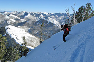
Sunday we started off with a tour from Big Cottonwood Canyon to Mill Creek via Reynolds Peak, the Wilson Chutes and Gobbler's Knob. Lots of ridge walking in the sun, and great settled, soft and consistent powder on the north facing shots. With a car stashed in Mill Creek, we got to ski out over 4,000' down the NW side of Gobbler's in amazing snow as well. I'll let the google earth image and the photos do the rest of the talking.

Google Earth image with our tour drawn in


Walking along Gobbler's Knob Summit Ridge


Richard drops into the Wilson Chutes


Looking 4,500' down the last run of the day to Porter Fork!

Today (Monday) we decided to tackle the crown jewel of the Wasatch, Mt. Superior, with some skiing in Cardiac Bowl and a long and beautiful ski out Mineral Fork. We went for the long ascent of the East Ridge of Superior for the added ski mountaineering aspect of the day and summit climb. Once again some great north facing settled powder and some billy goating on ridges and entrances so we can sneak into Mineral Basin where hardly anyone had been. Maps and photos will give you the full picture instead of my babbling...

The East Ridge of Superior. Classic.


Hiking up the East Ridge.


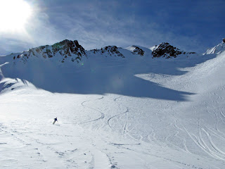
Dreamy and creamy turns down from the Summit of Superior.


Poking around to find the entrance into Mineral Fork


Mineral Fork void of tracks


Some more google earth images of the tour. I think red was up and blue lines were down!

Get out there and enjoy it while you can, I have 4 more days until I head back up to the land of snow (Canada). The weather forecast says atleast 2 more days of high pressure here in Salt Lake though...hmmmm.

Labels: , ,

0 comments

Wednesday, September 17, 2008

Fall is in the air!

I cruised up Timpanogos on Monday with my wife. Her first summit! The day was phenemonal, perfect weather, chilly temperatures, and the colors are beginning to change.

Primrose Cirque, Timpanogos.

Mountain goats in Timpanogos Basin with their fat winter coats from the Timpanogos hike on Monday.


Fall colors from 2007. Good for some fall hiking/climbing stoke.
Timpanogos from Cascade Mountain.

Second Summit, Timpanogos.


Labels: , , , ,

0 comments

Tuesday, August 12, 2008

Getting it done on Lone Peak

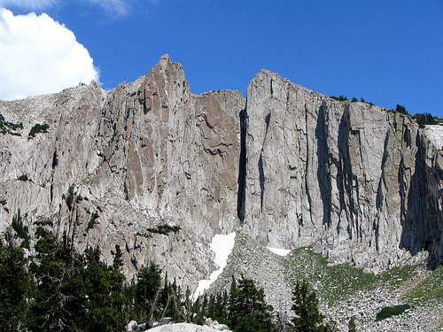
Lone Peak near Salt Lake City is just enough of a haul to get there that it limits the number of travelers. Steep granite walls beacon to the climber and hiker alike as the alpine setting with the city backdrop of the Salt Lake and Utah Valleys is a unique experience.

I was over at Summitpost.org and spotted a very well done trip report with some top notch photos like the one above.

This peak is worth the trip whether you are hiking to the summit or climbing its steep walls and despite being within view of a metro area like Salt Lake I've found that it still feels a world apart when you're up there.

Check out the full Trip Report of Lone Peak at Summitpost.org

--image credit Rocky Alps

Labels: ,

0 comments

Tuesday, February 05, 2008

The 10,000 Foot Day

It seems to me that almost every outdoor activity that I partake in has a certain benchmark challenge associated with it. For backcountry skiing, I would have to say that it is the 10,000 vertical foot day of touring. Sure, there are plenty of superstars out there that have pounded out 50 grand in 24 hours (www.greghill.ca), but to go out and get 10,000 feet of turns under human power is a great achievable goal for everyone (well, almost everyone).

Although to make it a spectacular experience, a bunch of key ingredients have to come together and today was one of those truly amazing Wasatch ski days. It has been puking non-stop here in Utah for weeks now. Alta's base is in the 150" range, the snowpack doesn't have many funky layers in it, and it just finished storming about 3 feet in the last 2 days. Of course I haven't been letting the snow settle for the last two days, with all of the new accumulation, I had to get out on Sunday and Monday, and logged in 14 grand over those two days. But today, Tuesday, was coming together to be the day. Storm snow and avalanche danger was settling down, blue skies were forecast, and the partners, Jasmin (my wife) and Adam were very keen. So the plan was simple, a variation on the famous "Northern Powder Circuit," starting in Alta and skiing down into Big Cottonwood Canyon. We met at 7am at Adam's house, loaded up the car, and bolted for Big Cottonwood Canyon's park and ride lot to stash the car. We geared up and by 7:30am we were thumbing it for a ride up to Alta.


I barely had time to snap a photo, as the first car that pulled over was heading to Alta and had room for the three of us! Perfect.

8 am and we were at Alta, witnessing the results of a classic Wasatch dawn patrol. A handfull of my buddies had just ripped down Little Superior, and we chatted at the cars as they got ready to go to work. They didn't have to say a word about the quality of the skiing, as snow plastered all over their hats was a true indicator. Not to mention the state of a few cars in the parking lot. Check out the antennae I circled:

Time for the first stage of the plan to take effect. Up Flagstaff, back down in the sun to Alta, back up Flagstaff, down Day's Fork. Wow. The powder was deep and light and turns came easy, except for cold faces.

In classic Wasatch style, the backcountry enthusiasts were out in force...bonus for us for the big day, as we didn't have to break too much trail in the 3 feet of unsettled cold smoke. Not to mention the fact that there was tons of room for us to make turns.

Stage 2 of the day got us away from the crowds a little more-but with a catch. We got to the top of a run called 'Banana Days' and skied that shot down another 1,500 feet. As a testament to the beauty of the day, we ran into the Powderwhores film crew getting some shots for their next installment. We pulled onto the summit with a few of that crew, just in time to watch the infamous heli ski operation of the Wasatch, Wasatch Powder Birds, land nearby to ski the same shot as us. Fast transitions were pulled off, and before I knew it Jasmin was ripping down the run, not about to be smoked by some heli-skiers after we had earned our turns!

We skied the lap, and busted a heavy track back up to Banana Days for the next segment of our 10,000 foot operation: The Hallway Couloir, one of my favorite runs in the Wasatch! We worked our way down and found the entrance to the line and enjoyed 1,800' of tight chute and open apron powder bliss down into Cardiff Fork. Here's a shot of Jasmin dropping into the Hallway with a few feet of fresh and a few thousand feet of it below her skis!

We hit the valley bottom and were in the Powder Birds frenzy as helicopters, and heli-skiers were everywhere, skiing the same lines we were enjoying under human power. It was hard not to feel self-righteous - wouldn't you? We stumbled onto another group's track up George's Bowl, as we neared 7,000' for the day. Ahead of us lay 1,500' of more powder bliss, so we took our only double lap of the day on George's bowl...it was just too good to be true. We managed to find some room for turns, despite the heli-traffic, but it was hard for us not to get into the debate about whether or not heli-skiing should be allowed in the central Wasatch...I would love to hear some opinions on this one.

On top of the second lap, the helicopter flew up, spotted us in the landing zone and turned around...at least they respected our space a bit.

After two runs, and a climb back to the top of George's bowl, our mission was accomplished: 10 grand (and 50 extra feet!). Here's where my Suunto S6 watch is super handy...I can track the vertical all day, while running my log book. Handy mountain guide geek tool altimeter watch that every backcountry skier should have!

Now it was 4pm, we had been at it for 8 hours and reached our goal. It was time for one last rip down Mineral Fork, with a few grand of blower powder waiting to get some tracks in it. The sun was still out, the city was in the distance, and the mission was accomplished. The pub was calling us for some nachos and beverages!
Or so we thought...one more adventure besides hitchhiking down to our cars awaited. The trail out Mineral Fork was being guarded by Bullwinkle. And he was pissed off with all this snow, because life is tough when you can't go to the pub for nachos.


We teamed up, tried to scare him down the trail, but he charged us and we skied down into the creek as fast as we could, forcing an unplanned stream crossing, and post hole up to the road.

10 grand don't come easy.

Labels: , , , ,

1 comments

Wednesday, January 30, 2008

How Deep is Too Deep?

Okay, so I just scored a copy of Powderwhore O7 (which by the way, is a pretty fun way to spend an hour of your life to get fired up for charging on the snow) and watched it two days ago. Besides the ripping tele skiing footage, the question is asked at the end of the video, whether it is ever too deep for skiing. Now I can pose you all with the same question, and present first hand documentation of a day that just might be too deep, but that is for you to decide.

This morning started out typical enough. Wake up at 5am, meet the ski partners Adam and backcountry.com's very own Tommy (who might have been skipping out on work?!!!??) for an early AM Wasatch style slacker dawn patrol. A few quick phone calls tell us that both Big and Little Cottonwood Canyons are closed for control work, so we already know that turns won't come easy. It has snowed about 35 inches in the last 40 hours. So with our fate of Mill Creek Canyon decided, we start hauling up the gradual climb into Porter Fork.

Down low in the early morning light, trailbreaking is easy enough: boot top powder, staying dry while it continues to dump in my super light Outdoor Research Synapse Jacket, but not over heating, and chit chatting the morning away. Slowly we climb, until about 2,000' later we realize progress is being slowed tremendously, and the question of 'How deep is too deep?' is pondered. It shouldn't take you too long to notice the WAIST high trench that I am plowing!

You might start to think, as I am, that maybe it is too deep? However, there is more evidence for you to examine. Here is exhibit B, a short video clip to show the speed and efficiency taking place this morning, in an attempt to ski some powder:


At least there was 3 of us to break trail, so the novelty gets to refresh itself every 5 minutes or so. However, we need to examine the evidence from the other side of the coin...the downhill evidence. So here for you to examine is exhibits C and D. The first shot here is of Tommy skipping work, but to his luck, you can't really tell it's him, so he might just stay out of trouble.

The second shot though, is definitely some good proof, that maybe its not too deep, or even if it is, we can still laugh about it...then again Adam's face might be frozen in the single digit temps after sticking his mug shot in the snowmaking gun for a few turns!

In the end, we all decided that we had experienced enough of the ridiculously deep powder, and would glide down the canyon to resume our other responsibilities. At least we still got to debate the question of if it is ever really too deep...what do you think?

Labels: , , , ,

3 comments

Tuesday, July 31, 2007

Hybrid Pedal Dinner in Logan Utah


The Nordic United and Winter Wildlands are hosting a dinner this Saturday, August 4th, from 6-8pm at the Spring Hollow Campground in Logan Canyon. The dinner will include hanging with the Keen Footwear Hybrid Pedal tour riders and talk about winter recreation issues in Logan Canyon.

The purpose of the event is to round up support to protect quiet winter use in the canyon near Franklin Basin. Come and show your outdoor-lovin' support, dinner and drinks are from 6-8pm and it's free for WWA & NU members and $5 for non-members.

CAUTION: This event may get you itching for ski season!

Hybrid Pedal is a 1,000 mile cycling initiative to generate awareness and raise money for the Conservation Alliance, that is dedicated to protecting wild places for the habitat and recreation value. They are making a documentary film of the ride that will be shown at the Outdoor Retailer trade show in Salt Lake City next week.

Backcountry.com is super stoked to have organizations like Nordic United to keep our Wasatch runs pure and motorized-vehicle free.

The Nordic United Blog is also a great resource for Wasatch skiing.

For information about the dinner call (435) 753-5031
RSVP to info@winterwildlands.org

Labels: , ,

2 comments